
Groundwater methodologies#
Warning
Last updated - 2026-07-02
Changes based on feedback from WG DIS and WG Groundwater members.
Removal of the GWType related classes.
Purpose and overview#
This section:
revises the information related to Groundwater methodologies in the 2nd and 3rd cycle of reporting of the Water Framework Directive River Basin Management Plans
presents a simplified proposal for the electronic reporting in the 4th cycle
GWMET_2022 schema - 3rd cycle#
The GWMET_2022 schema defined the required data about about the groundwater methodologies (Figure 56).
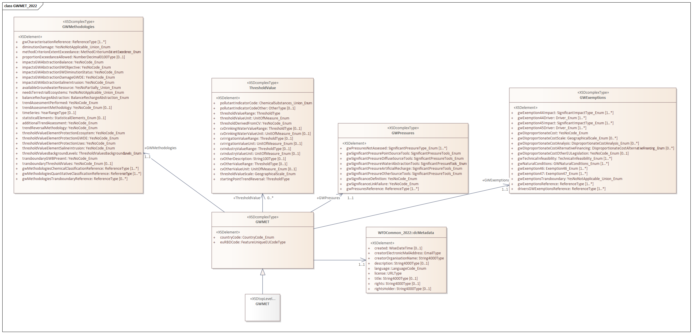
Figure 56 GWMET_2022 Schema - 3rd cycle#
The GWMET_2022 schema was already partially revised (see Reporting of exemptions - 3rd cycle). Specifically, the GWExemptions data (Figure 36) is no longer requested in the 4th cycle.
Figure 57 shows a simplified diagram to help focus the discussion on the remaining issues.
        ---
config:
  class:
    hideEmptyMembersBox: true
  layout: dagre
  theme: default
---
classDiagram

class GWMethodologies {
  + gwCharacterisationReference: ReferenceType [1..*]
  + diminutionDamage: YesNoNotApplicable_Union_Enum
  + methodCriterionExtentExceedance: MethodCriterionExtentExceedance_Enum
  + proportionExceedanceAllowed: NumberDecimal0100Type [0..1]
  + impactsGWAbstractionBalance: YesNoCode_Enum
  + impactsGWAbstractionSWObjective: YesNoCode_Enum
  + impactsGWAbstractionSWDiminutionStatus: YesNoCode_Enum
  + impactsGWAbstractionDamageGWDE: YesNoCode_Enum
  + impactsGWAbstractionSalineIntrusion: YesNoCode_Enum
  + availableGroundwaterResource: YesNoPartially_Union_Enum
  + needsTerritorialEcosystems: YesNoNotApplicable_Union_Enum
  + balanceRechargeAbstraction: BalanceRechargeAbstraction_Enum
  + trendAssessmentPerformed: YesNoCode_Enum
  + trendAssessmentMethodology: YesNoCode_Enum [0..1]
  + timeSeries: YearRangeType [0..1]
  + statisticalElements: StatisticalElements_Enum [0..1]
  + additionalTrendAssessment: YesNoCode_Enum
  + trendReversalMethodology: YesNoCode_Enum
  + thresholdValueElementProtectionEcosystem: YesNoCode_Enum
  + thresholdValueElementProtectionGWDE: YesNoCode_Enum
  + thresholdValueElementProtectionUses: YesNoCode_Enum
  + thresholdValueElementSalineIntrusion: YesNoCode_Enum
  + thresholdValueBackgroundLevels: ThresholdValueBackgroundLevels_Enum
  + transboundaryGWBPresent: YesNoCode_Enum
  + transboundaryThresholdValues: YesNoCode_Enum
  + gwMethodologiesChemicalStatusClassificationReference: ReferenceType [1..*]
  + gwMethodologiesQuantitativeClassificationReference: ReferenceType [1..*]
  + gwMethodologiesTransboundaryReference: ReferenceType [0..*]
}

class GWPressures{
  + gwPressuresNotAssessed: SignificantPressureType_Enum [1..*]
  + gwSignificantPressurePointSourceTools: SignificantPressureTools_Enum
  + gwSignificantPressureDiffuseSourceTools: SignificantPressureTools_Enum
  + gwSignificantPressureWaterAbstractionTools: SignificantPressureTools_Enum
  + gwSignificantPressureArtificialRecharge: SignificantPressureTools_Enum
  + gwSignificantPressureOtherSourceTools: SignificantPressureTools_Enum
  + gwSignificanceDefinition: YesNoCode_Enum
  + gwSignificanceLinkFailure: YesNoCode_Enum
  + gwPressuresReference: ReferenceType [1..*]
}


class ThresholdValue{
  + pollutantIndicatorCode: ChemicalSubstances_Union_Enum
  + pollutantIndicatorCodeOther: OtherType [0..1]
  + thresholdValueRange: ThresholdType [0..1]
  + thresholdValueUnit: UnitOfMeasure_Enum
  + thresholdValueDerivedFromCV: YesNoCode_Enum
  + cvDrinkingWaterValueRange: ThresholdType [0..1]
  + cvDrinkingWaterValueUnit: UnitOfMeasure_Enum [0..1]
  + cvIrrigationValueRange: ThresholdType [0..1]
  + cvIrrigationValueUnit: UnitOfMeasure_Enum [0..1]
  + cvIndustryValueRange: ThresholdType [0..1]
  + cvIndustryValueUnit: UnitOfMeasure_Enum [0..1]
  + cvOtherValueRange: ThresholdType [0..1]
  + cvOtherValueUnit: UnitOfMeasure_Enum [0..1]
  + thresholdValueScale: GeographicalScale_Enum
  + startingPointTrendReversal: ThresholdType
}


class GWMET {
  + countryCode: CountryCode_Enum
  + euRBDCode: FeatureUniqueEUCodeType
}

GWMethodologies <-- GWMET : 1..1
GWPressures <-- GWMET : 1..1
ThresholdValue <-- GWMET : *..0
Figure 57 Class diagram for the GWMET_2022 schema in the 3rd cycle.#
The Commission has revised and simplified the GWMethodologies class, keeping only a subset of the elements requested in the 3rd cycle. The following elements were removed:
GWMET/GWMethodologies/diminutionDamage
GWMET/GWMethodologies/methodCriterionExtentExceedance
GWMET/GWMethodologies/proportionExceedanceAllowed
GWMET/GWMethodologies/impactsGWAbstractionBalance
GWMET/GWMethodologies/impactsGWAbstractionSWObjective
GWMET/GWMethodologies/impactsGWAbstractionSWDiminutionStatus
GWMET/GWMethodologies/impactsGWAbstractionDamageGWDE
GWMET/GWMethodologies/impactsGWAbstractionSalineIntrusion
GWMET/GWMethodologies/availableGroundwaterResource
GWMET/GWMethodologies/needsTerritorialEcosystems
GWMET/GWMethodologies/balanceRechargeAbstraction
GWMET/GWMethodologies/gwMethodologiesChemicalStatusClassificationReference
GWMET/GWMethodologies/gwMethodologiesQuantitativeClassificationReference
GWMET/GWMethodologies/gwMethodologiesTransboundaryReference
GWMET/GWMethodologies/transboundaryGWBPresent
GWMET/GWMethodologies/trendAssessmentMethodology
The following elements were moved or revised:
GWMET/GWMethodologies/trendAssessmentStatisticalElements
GWMET/GWMethodologies/thresholdValueBackgroundLevels
The Commission has revised and simplified the ThresholdValue class, keeping only a subset of the elements requested in the 3rd cycle. The following elements were removed:
GWMET/ThresholdValue/pollutantIndicatorCodeOther
GWMET/ThresholdValue/thresholdValueDerivedFromCV
GWMET/ThresholdValue/cvDrinkingWaterValueRange
GWMET/ThresholdValue/cvDrinkingWaterValueUnit
GWMET/ThresholdValue/cvIrrigationValueRange
GWMET/ThresholdValue/cvIrrigationValueUnit
GWMET/ThresholdValue/cvIndustryValueRange
GWMET/ThresholdValue/cvIndustryValueUnit
GWMET/ThresholdValue/cvOtherValueRange
GWMET/ThresholdValue/cvOtherValueUnit
GWMET/ThresholdValue/thresholdValueScale
The Commission has revised GWPressures class. The following elements were removed:
GWMET/GWPressures/gwSignificantPressureOtherSourceTools
GWMET/GWPressures/gwPressuresNotAssessed
GWMET/GWPressures/gwPressuresReference
The structure of the GWPressures class was also revised.
Descriptive dataset - 4th cycle#
This section shows the proposed structure for the groundwater methodologies reporting.
GWMethodologies table#
The GWMethodologies table has a structure similar to the corresponding class
in the 3rd cycle reporting, minus the attributes removed by the Commission’s review
(see Figure 58).
        ---
config:
  class:
    hideEmptyMembersBox: true
  layout: dagre
  theme: neutral
  themeVariables:
    noteBkgColor: LightYellow
    noteTextColor: black
---
classDiagram

class GWMethodologies {
  + euRBDCode: wiseIdentifier
  + gwCharacterisationReference: referenceCode
  + trendAssessmentPerformed: YesNo
  + trendAssessmentTimeSeries: range [0..1]
  + trendAssessmentStatisticalMethod: TrendStatisticalMethod [0..1]
  + additionalTrendAssessment: YesNo
  + trendReversalMethodology: YesNo
  + thresholdValueElementProtectionEcosystem: YesNo
  + transboundaryThresholdValues: YesNoNotApplicable
  + thresholdValueElementProtectionGWDE: YesNo
  + thresholdValueElementProtectionUses: YesNo
  + thresholdValueElementSalineIntrusion: YesNo
}

class TrendStatisticalMethod{
  <<enumeration>>
  statisticalSignificanceTrendDetection
  confidenceIntervalTrendMagnitude
  none
}

GWMethodologies .. TrendStatisticalMethod

classDef default fill:white,stroke:#000;
classDef otherDataset fill:lightyellow,stroke:#000;
classDef forFixing fill:white,stroke:#f00;
Figure 58 Groundwater methodologies - GWMethodologies table - 4th cycle#
GWPressureAssessment table#
The GWPressureAssessment table has a modified structure
(see Figure 59):
the reporting of “pressures not assessed” is eliminated, because the data was difficult to analyse and contained inconsistencies
instead, for each pressure (or group of pressures), three attributes are requested (
gwPressureAssessmentMethod,gwSignificanceDefinition,gwSignificanceLinkFailure)given that the pressure codelist is hierarchical, the granularity of the reporting is selected by Member States
the quality control procedure will verify that different levels are not selected simultaneously for any given RBD
For more information see PressureType codelist - 4th cycle.
        ---
config:
  class:
    hideEmptyMembersBox: true
  layout: dagre
  theme: neutral
  themeVariables:
    noteBkgColor: LightYellow
    noteTextColor: black
---
classDiagram

class GWPressureAssessment{
  + euRBDCode: wiseIdentifier
  + gwPressure: PressureType
  + gwPressureAssessmentMethod: PressureAssessmentMethod
  + gwSignificanceDefinition: YesNoNotApplicable
  + gwSignificanceLinkFailure: YesNoNotApplicable
}

class PressureAssessmentMethod{
<<enumeration>>
  numericalTools
  expertJudgement
  combinationOfBoth
  notAssessed
}

GWPressureAssessment ..> PressureAssessmentMethod

classDef default fill:white,stroke:#000;
classDef otherDataset fill:lightyellow,stroke:#000;
classDef forFixing fill:white,stroke:#f00;
Figure 59 Groundwater methodologies - GWPressureAssessment table - 4th cycle#
GWThresholdValue table#
The GWThresholdValue table has a structure similar to the corresponding class
in the 3rd cycle reporting, minus the attributes removed by the Commission’s review
(see Figure 60).
Note that:
a unique
gwThresholdIdentifierwas introduced to avoid ambiguityduplicate records will be detected (i.e. records with identical values for all attributes, except the identifier)
for naturally occurring substances, if natural background levels were taken into account in the definition of the threshold value, then the applicable
nblValueRangeis provided (in the same unit of measure as thethresholdValueRange)
        ---
config:
  class:
    hideEmptyMembersBox: true
  layout: dagre
  theme: neutral
  themeVariables:
    noteBkgColor: LightYellow
    noteTextColor: black
---
classDiagram
class GWThresholdValue{
  + gwThresholdIdentifier: wiseIdentifier
  + parameterCode: Parameter
  + thresholdValueRange: range
  + thresholdValueUnit: UnitOfMeasure

  + startingPointTrendReversal: range [0..1]
  «reference»
  + gwThresholdReference: referenceCode [0..n]
}

class GWPollutant ["GroundWaterDataset::GWPollutant"]:::otherDataset{
  + euGroundWaterBodyCode
  + gwPollutantCode
  + gwThresholdIdentifier
}

GWThresholdValue <.. GWPollutant: gwThresholdIdentifier

classDef default fill:white,stroke:#000;
classDef otherDataset fill:lavender,stroke:#000;
classDef forFixing fill:white,stroke:#f00;
Figure 60 Groundwater methodologies - GWThresholdValue table - 4th cycle#
Todo
Groundwater methodologies - GWThresholdValue For groundwater thresholds can the attribute standardType be omitted?
+ standardType : StandardType
Codelists - 4th cycle#
For the
PressureAssessmentMethodcodelist, see Table 68.For the
TrendStatisticalMethodcodelist, see Table 53.
TrendStatisticalMethod codelist
Notation |
Label |
Definition |
|---|---|---|
statisticalSignificanceTrendDetection |
Statistical significance |
The existence of a significant trend was assessed using statistical tests. |
confidenceIntervalTrendMagnitude |
Confidence interval |
The existence of a significant trend was assessed using statistical tests, the magnitude of the trend was quantified and the uncertainty was assessed using confidence intervals. |
none |
None |
The trend assessment did not use statistical methods (i.e. expert judgement only) |
Documents dataset - 4th cycle#
The Documents dataset follows the standard structure used in various WISE dataflows (Figure 85):
the
dcMetadatatable provides the basic Dublin Core metadata elements about the deliveryif required by the data providers, and especially if spatial data is being reported, the
licenseDocumentand themetadataDocumentattributes allow the provision of additional information about the datasetthe
dcMetadatatable also functions as a “manifest file” explaining if the delivery contains data for a given river basin district or not
the
Documenttable allows the upload of documents (for example, PDFs) or the provision of ahyperlinkto a document stored in a publicly accessible national web sitethe
Referencetable is also standard in the WISE dataflows: thebookmarkit allows the identification of the chapter(s), sections(s) or page range(s) where the relevant information about asubjectcan be found within a document
The following criteria apply:
the
dcMetadatatable must contain one and only one record for each of the country’s river basin districts, identified by theeuRBDCodefor countries reporting under the WFD, the quality control will raise an ERROR, if some, or all, the river basin districts have
includesDescriptiveData = no
        ---
config:
  class:
    hideEmptyMembersBox: true
  layout: dagre
  theme: neutral
---
classDiagram
direction LR

class dcMetadata {

«metadata»
+ title: string
+ creatorOrganisationName: string
+ creatorElectronicMailAddress: Email
+ description: string [0..1]
+ created: date [0..1]
+ language: Language [1..n]
+ license: Licence
+ rights: string [0..1]
+ rightsHolder: string [0..1]
+ licenseDocument: documentCode [0..n]
+ metadataDocument: documentCode [0..n]

«data-delivery-manifest»
+ euRBDCode: wiseIdentifier
+ includesMonitoringData: YesNo
}

class Reference {
  + referenceCode: wiseIdentifier
  + documentCode: documentCode
  + bookmark: string250
  + subject: string250
}

class Document {
+ documentCode: wiseIdentifier
+ documentName: string250
+ hyperlink: URL [0..1]
+ documentFile: Attachment [0..1]
}

class Licence{
  <<enumeration>>
  CC0
  CC_BY_4_0
  exactMatch_CC_BY_4_0
  narrowMatch_CC_BY_4_0
}

Reference  ..> Document: documentCode
dcMetadata ..> Document: licenseDocument
dcMetadata ..> Document: metadataDocument
dcMetadata ..> Licence: license
classDef default fill:white,stroke:#000;
classDef forFixing fill:white,stroke:#f00;
Figure 61 GroundWaterMethodologies - 4th cycle - Documents#
Annexes - Data analysis - 3rd cycle#
trendAssessmentMethodology#
The WFD2022 guidance document definitions for the trendAssessmentPerformed, trendAssessmentMethodology and statisticalElements elements of the GWMethodologies class are transcribed in Table 54.
Attribute |
Guidance |
Option |
|---|---|---|
trendAssessmentPerformed |
Required. |
‘Yes’ |
trendAssessmentMethodology |
Conditional. |
‘Yes’ |
statisticalElements |
Conditional. |
‘Statistical significance’ |
The reported data for combinations of the three elements is presented in Table 55.
The first four records may be interpreted as:
in 95 river basin districts, trends were assessed and a test for statistical significance of an upward trend was used
(e.g. using a linear regression t-test or a non-parametric Mann-Kendall test)in 36 river basin districts, trends were not assessed
in 16 river basin districts, trends were assessed and the magnitude of significant upward trends was quantified using confidence intervals
in 2 river basin districts, trends were assessed but no methodology for detecting significant upward trends exists, and no statistical element was used (i.e. only expert judgement was used?)
The last two records are difficult to interpret, and possibly result from reporting mistakes:
in 6 river basin districts trends were assessed, a methodology for detecting significant upward trends was applied, but somehow no statistical element was used
in 1 river basin districts trends were assessed, a methodology for detecting significant upward trends was not applied, but somehow statistical significance was determined
In conclusion:
the trendAssessmentMethodology element appears to be redundant with respect to the statisticalElements element, and may be removed to simplify the reporting and avoid mistakes
the meaning of the statisticalElements element should be made clearer to both data provider and end-users, to facilitate the interpretation
trendAssessmentPerformed |
trendAssessmentMethodology |
statisticalElements |
numberOfRBDs |
numberOfCountries |
|---|---|---|---|---|
Yes |
Yes |
Statistical significance |
95 |
20 |
No |
«null» |
«null» |
36 |
5 |
Yes |
Yes |
Confidence intervals |
16 |
6 |
Yes |
No |
None |
2 |
1 |
Yes |
Yes |
None |
6 |
2 |
Yes |
No |
Statistical significance |
1 |
1 |