
Groundwater bodies#
Warning
Last updated - 2026-07-02
Changes based on feedback from WG DIS and WG Groundwater members.
The “lithology placeholder” was removed.
The gwAtRiskQuantitative and gwReasonsForRiskQuantitative attributes were reintroduced.
The gwPollutantCausingRisk and gwPollutantBackgroundLevelSet attributes were reintroduced.
Further information about the 3rd cycle reporting of natural background levels was included GroundWaterBody - 3rd cycle - Parameters with reported Natural Background Level.
Purpose and overview#
This section revises the reporting of information related to Groundwater Bodies in the 2nd and 3rd cycle of reporting of the Water Framework Directive River Basin Management Plans. It also presents a proposal for simplifying the electronic reporting in the 4th cycle.
Current structure - 3rd cycle#
In the 3rd cycle, the information about Groundwater bodies was reported in 4 separate schemas:
the GWB_2022 schema, containing information about each groundwater body (Figure 48)
the GWMET_2022 schema, containing information about the methodologies (see Groundwater methodologies)
the GML_GroundWaterBody_2022 schema, containing the GroundWaterBody spatial dataset.
the GML_GroundWaterBodyHorizon_2022 schema, containing the ancillary GroundWaterBodyHorizon spatial dataset.
GWB_2022 schema - 3rd cycle#
The GWB_2022 schema was already partially revised with regard to the reporting of exemptions. See:
Other simplifications already discussed also apply to the GWB schema:
removal of the textual reporting of “other” pollutants
removal of the textual reporting of “other” pressures
removal of the textual reporting of “other” impacts
The Commission has revised the GroundWaterBody class, and removed the following elements:
GWB/GroundWaterBody/gwEORiskQuantitative
GWB/GroundWaterBody/gwEORiskChemical
GWB/GroundWaterBody/gwAtRiskQuantitative
GWB/GroundWaterBody/gwAtRiskChemical
GWB/GroundWaterBody/gwReasonsForRiskQuantitative
The Commission has revised the GWPollutant class, and removed the following elements:
GWB/GroundWaterBody/GWPollutant/gwPollutantExceedancesNotCounted
        ---
config:
  class:
    hideEmptyMembersBox: true
  layout: dagre
  theme: default
---

classDiagram
class GWChemicalExemptionType ["«XSDcomplexType»
GWChemicalExemptionType"] {
  «XSDelement»
  + gwChemicalExemptionType: GWChemicalExemptionType_Union_Enum
  + gwChemicalExemptionPressure: SignificantPressureType_Enum
}

class GWPollutant ["«XSDcomplexType»
GWPollutant"]{
  «XSDelement»
  + gwPollutantCode: ChemicalSubstances_Enum
  + gwPollutantOther: OtherType [0..1]
  + gwPollutantCausingRisk: YesNoUnknown_Linear_Union_Enum
  + gwPollutantCausingFailure: YesNoCode_Enum
  + gwPollutantUpwardTrend: YesNoUnknownUnknown_Linear_Union_Enum
  + gwPollutantTrendReversal: YesNoUnknownNotApplicable_Code_Enum
  + gwPollutantExceedancesNotCounted: YesNoUnknownCode_Enum
  + gwPollutantBackgroundLevelSet: YesNoCode_Enum
  + gwPollutantBackgroundLevelValue: ThresholdType [0..1]
  + gwPollutantBackgroundLevelUnit: UnitOfMeasure_Enum [0..1]
  + gwPollutantTrendReversalProcess: YesNoUnknownNotApplicableCode_Enum
}

class GWAssociatedProtectedArea ["«XSDcomplexType»
GWAssociatedProtectedArea"]{
  «XSDelement»
  + euProtectedAreaCode: FeatureUniqueEUCodeType
  + protectedAreaType: ProtectedGWAreaType_Enum
  + protectedAreaObjectivesSet: ProtectedAreaObjectivesEnum [0..1]
  + protectedAreaObjectivesMet: YesNoInformation_Union_Enum [0..1]
  + protectedAreaComment: String1000Type [0..1]
  + protectedAreaExemption: ExemptionType_Enum [1..*]
}

class GroundWaterBody ["«XSDcomplexType»
GroundWaterBody"] {
  «XSDelement»
  + euGroundWaterBodyCode: FeatureUniqueEUCodeType
  + linkSurfaceWaterBody: YesNoCode_Enum
  + linkSurfaceWaterBodyCode: FeatureUniqueEUCodeType [0..*]
  + linkTerrestrialEcosystem: YesNoUnknownCode_Enum
  + geologicalFormation: GeologicalFormation_Enum
  + groundwaterBodyTransboundary: YesNoCode_Enum
  + gwSignificantPressureType: SignificantPressureType_Enum [1..*]
  + gwSignificantPressureOther: String100Type [0..1]
  + gwSignificantImpactType: SignificantImpactType_Enum [1..*]
  + gwSignificantImpactOther: String1000Type [0..1]
  + gwAtRiskQuantitative: YesNoCode_Enum
  + gwReasonsForRiskQuantitative: QuantitativeFailure_Enum [0..*]
  + gwEoRiskQuantitative: GWERiskQuantitative_Enum [0..1]
  + gwQuantitativeStatusValue: StatusCode_Enum
  + gwQuantitativeReasonsForFailure: QuantitativeFailure_Enum [0..*]
  + gwQuantitativeAssessmentYear: YearRangeType
  + gwQuantitativeAssessmentConfidence: Confidence_Enum
  + gwQuantitativeStatusExpectedAchievementDate: GoodStatus_Enum
  + gwQuantitativeExemptionType: ExemptionType_Enum [1..*]
  + gwQuantitativeExemptionPressure: SignificantPressureType_Enum [0..*]
  + gwAtRiskChemical: YesNoCode_Enum
  + gwEoRiskChemical: EORiskChemical_Enum [0..1]
  + gwChemicalStatusValue: StatusCode_Enum
  + gwChemicalReasonsForFailure: ReasonsForFailure_Enum [0..*]
  + gwChemicalAssessmentYear: YearRangeType
  + gwChemicalAssessmentConfidence: Confidence_Enum
  + gwChemicalStatusExpectedAchievementDate: GoodStatus_Enum
}

class GWB ["«XSDcomplexType»
GWB"]{
  «XSDelement»
  + countryCode: CountryCode_Enum
  + euRBDCode: FeatureUniqueEUCodeType
}


GWAssociatedProtectedArea --> GroundWaterBody: GWAssociatedProtectedArea
GWPollutant --> GroundWaterBody: GWPollutant
GWChemicalExemptionType --> GWPollutant: GWChemicalExemptionType
GroundWaterBody --> GWB: GroundWaterBody
Figure 48 Class diagram for the GWB_2022 schema in the 3rd cycle.#
In the 4th cycle of reporting, the data will be delivered in the Reportnet3 platform:
the remaining GWMET_2022 classes and elements were reorganised into a relational model, as required by the migration to Reportnet3
selective denormalisation was used to keep a low number of tables and facilitate the quality control
the requirements of Directive 2006/118/EC also need to be taken into account
(36) In order to ensure a level playing field in the Union and allow comparability of water body status between Member States, there is a need to harmonise national threshold values for some man-made synthetic groundwater pollutants. Threshold values should be established as necessary at Union level for pollutants which have an anthropogenic origin or for the products of their degradation or decomposition, provided that those pollutants and degradation products either do not occur naturally in groundwater, or, if identical natural counterparts exist, provided that their natural background levels are, at most, low. Those threshold values should be included in the repository of harmonised threshold values for man-made synthetic substances in groundwater of national, regional or local concern in a new Part D of Annex II to Directive 2006/118/EC. A harmonised threshold value for individual pharmaceuticals should be included for application by Member States to any pharmaceutical active substance identified as posing a risk at national level unless a stricter standard or threshold value has been set specifically for that substance at Union or national level.
(37) All provisions of Directive 2006/118/EC relating to the assessment of groundwater chemical status should be adapted to the introduction of the third category of harmonised threshold values in a new Part D of Annex II to that Directive, in addition to the quality standards set out in Annex I to that Directive and the national threshold values set out in accordance with the methodology set out in Part A of Annex II to that Directive.
Groundwater - descriptive data - 4th cycle#
The proposed structure for the 4th cycle electronic reporting is presented in the class diagram in Figure 49 and a brief description of each table is included in Table 44.
The core data about each groundwater body is reported in 3 tables:
GroundWaterBody,LinkSurfaceWaterBodyandGWNaturalBackgroundLevel.The content of this set of tables does not depend of the status assessment, and can be prepared in advance.
A second set of tables contains information about the chemical and quantitative status assessment and about pressures and impacts:
GroundWaterBodyStatus,GWQuantitativeStatus,GWPollutantandGWPressureImpact.The ancillary table
GWGroupingsupports the reporting of grouping (if used the assessment).A link to the
GWMethodologies::ThresholdValuetable clarifies which threshold value is applied to each pollutant.
(A list of the default EU threshold values will be provided where defined by the EU legislation.)
        ---
config:
  class:
    hideEmptyMembersBox: true
  layout: dagre
  theme: neutral
  themeVariables:
    noteBkgColor: LightYellow
    noteTextColor: black
---
classDiagram
direction TB

class GWLinkSurfaceWaterBody{
    + euGroundWaterBodyCode: wiseIdentifier
    + euSurfaceWaterBodyCode: wiseIdentifier
    + linkType: GroundwaterSurfaceWaterLink
}

class GWNaturalBackgroundLevel{
    + euGroundWaterBodyCode: wiseIdentifier
    + parameterCode: Parameter
    + naturalBackgroundLevelSet: YesNo
    + parameterValue: range [0..1]
    + parameterUnit: UnitOfMeasure [0..1]
}

class GroundWaterBody{
    + euGroundWaterBodyCode: wiseIdentifier
    + aquiferType: AquiferMediaTypeValue
    + aquiferProductivity: AquiferProductivity
    + groundWaterBodyTransboundary: YesNo
    + linkSurfaceWaterBody: YesNo
    + linkTerrestrialEcosystem: YesNoUnknown
}

class GWQuantitativeStatus{
    + euGroundWaterBodyCode: wiseIdentifier
    + gwQuantitativeStatusValue: QuantitativeStatus
    + gwQuantitativeAssessmentPeriod: range
    + gwQuantitativeAssessmentConfidence: AssessmentConfidence
    + gwQuantitativeAssessmentMethod: AssessmentMethod [1..n]
    + gwGroupingIdentifier: wiseIdentifier [0..n]

    + gwAtRiskQuantitative: YesNo
}

class GWPressureImpact{
    + euGroundWaterBodyCode: wiseIdentifier
    + gwPressureType: PressureType [0..1]
    + gwImpactType: ImpactType  [0..1]
}

class GWStatus{

    + euGroundWaterBodyCode: wiseIdentifier
    + gwQuantitativeStatusValue: QuantitativeStatus
    + gwChemicalStatusValue: ChemicalStatus

    + gwQuantitativeReasonsForFailure: ReasonForFailure [1..n]
    + gwQuantitativeReasonsForRisk: ReasonForFailure [1..n]
    + gwChemicalReasonsForFailure: ReasonForFailure [1..n]
}

class GWPollutant{
    + euGroundWaterBodyCode: wiseIdentifier
    + gwPollutantCode: Parameter

    + gwThresholdIdentifier: wiseIdentifier
    + gwGroupingIdentifier: wiseIdentifier [0..n]
    + gwPollutantCausingFailure: YesNoUnknown
    + gwPollutantAssessmentPeriod: range
    + gwPollutantAssessmentConfidence: AssessmentConfidence
    + gwPollutantAssessmentMethod: AssessmentMethod [1..n]

    + gwPollutantCausingRisk: YesNoUnknown

    + gwPollutantUpwardTrend: YesNoUnknownNotAssessed
    + gwPollutantTrendReversal: YesNoUnknownNotApplicableNotAssessed
    + gwPollutantTrendReversalProcess: YesNoUnknownNotApplicableNotAssessed

}

class GWGrouping{
    + gwGroupingIdentifier: wiseIdentifier
    + euGroundWaterBodyCode: wiseIdentifier
}

GroundWaterBody "1" -- "1" GWStatus
GWStatus "1" -- "0..1" GWQuantitativeStatus
GWStatus "1" -- "0..n" GWPollutant
GWStatus "1" -- "0..n" GWPressureImpact

GWQuantitativeStatus ..> GWGrouping: gwGroupingIdentifier
GWPollutant ..> GWGrouping: gwGroupingIdentifier

GWLinkSurfaceWaterBody "0..n" -- GroundWaterBody: {linkSurfaceWaterBody = 'Yes'}
GWNaturalBackgroundLevel "0..n" -- GroundWaterBody

GWNaturalBackgroundLevel .. GWPollutant: {quality control}

%% note for GWPollutant "GroundwaterMethodologies::ThresholdValue.gwThresholdIdentifier"

classDef default fill:white,stroke:#000;
classDef forFixing fill:white,stroke:#f00;
Figure 49 Groundwater - descriptive data - 4th cycle#
Table |
Description |
|---|---|
GroundWaterBody |
modified The In the 3rd cycle, the reporting guidance requested description of
“the main geological formation of the aquifer type”.
The usability of the reported data was limited,
beyond visualisation purposes. |
GWLinkSurfaceWaterBody |
modified. |
GWNaturalBackgroundLevel |
modified |
GWStatus |
new Formally, the Likewise, the |
GWPollutant |
modified |
GWQuantitativeStatus |
new |
GWGrouping |
new The |
GWPressureImpact |
modified. For water bodies that do not achieve good chemical status in 2027,
the significant pressures are reported in the For cases where a pressure is not causing failure,
but still causes an impact that needs to be managed,
the Note that the reporting of pressures and impacts
is combined into a single |
Groundwater - codelists - 4th cycle#
For the
AquiferMediaTypeValuecodelist, see Figure 50.
The codelist was realigned with the INSPIRE codelist to allow more flexibility.See the definitions in Table 45.
For the
AquiferProductivitycodelist, see Figure 50.
The codelist allows the reporting of aquifer productivity independently of the aquifer media values.
Further technical guidance on concepts, classification schemes and class boundaries is needed.[1]See the definitions in Table 46.
For the
AssessmentMethodcodelist, see Figure 51.
The codelist is used to report the assessment method for the chemical status and for the quantitative status.
The same codelist is used for surface water bodies, for the assessment method of ecological status or potential, and for the assessment method of chemical status.See the definitions in Table 47.
For the
AssessmentConfidencecodelist, see also Figure 51.
The codelist allow the reporting of the level of confidence in the results of the status assessment.
The same codelist is used for surface water bodies. See also [2] [3] [4].See the definitions in Table 48.
For the
GroundwaterSurfaceWaterLinkcodelist, see Figure 52.
The codelist is used to report the type of link between a given groundwater body and a given surface water body.See the definitions in Table 49.
For the
ReasonForFailurecodelist, see Figure 53.See the definitions in Table 50.
For groundwater bodies in poor quantitative status, the codelist values are used in the
gwQuantitativeReasonsForFailureattribute to provide further information about one or more causes of failure (the most frequent cause will be likely be'waterBalance').
For groundwater bodies in good or unknown quantitative status, the optionnotApplicablemust be used.For groundwater bodies failing to achieve good chemical status, the codelist values are used in the
gwChemicalReasonsForFailureattribute to provide further information about one or more causes of failure (the most frequent cause will be likely be'waterQuality').
For groundwater bodies in good or unknown quantitative status, the optionnotApplicablemust be used. For groundwater bodies in good or unknown chemical status, the optionnotApplicablemust be used.For groundwater bodies where good quantitative status is at risk, the codelist values are used in the
gwQuantitativeReasonsForRiskattribute to provide further information about one or more causes of risk. For groundwater bodies wheregwAtRiskQuantitative = 'no'the optionnotApplicablemust be used.
For the
PressureTypecodelist, see Figure 86 in the section PressureType codelist - 4th cycle
        ---
config:
  class:
    hideEmptyMembersBox: true
  layout: dagre
  theme: neutral
---
classDiagram
direction TB

class AquiferMediaTypeValue{
<<enumeration>>
compound
fractured
karstic
karsticAndFractured
porous
porousAndFractured
other
unknown
}

class AquiferProductivity{
<<enumeration>>
high
moderate
low
insignificant
unknown
}

classDef default fill:white,stroke:#000;
classDef forFixing fill:white,stroke:#f00;
Figure 50 AquiferMediaTypeValue codelist and AquiferProductivity codelist - 4th cycle#
Notation |
Label |
Definition |
URI |
|---|---|---|---|
compound |
Compound |
A combination of a porous, karstic and/or fractured aquifer. |
https://inspire.ec.europa.eu/codelist/AquiferMediaTypeValue/compound |
fractured |
Fractured |
Fractured aquifers are rocks in which the primary porosity is negligible and the water circulation is through the secondary porosity (fractures, faults, joints, bedding planes). |
https://inspire.ec.europa.eu/codelist/AquiferMediaTypeValue/fractured |
karstic |
Karstic |
Karstic aquifers are fractured aquifers where the cracks and fractures have been enlarged by solution, forming large channels or even caverns. |
https://inspire.ec.europa.eu/codelist/AquiferMediaTypeValue/karstic |
karsticAndFractured |
Karstic and fractured |
A combination of karstic and fractured aquifer. |
https://inspire.ec.europa.eu/codelist/AquiferMediaTypeValue/karsticAndFractured |
porous |
Porous |
Porous aquifers are unconsolidated or consolidated deposits where water circulates through pores between the grains. |
https://inspire.ec.europa.eu/codelist/AquiferMediaTypeValue/porous |
porousAndFractured |
Porous and fractured |
A combination of porous and fractured aquifer. |
https://inspire.ec.europa.eu/codelist/AquiferMediaTypeValue/porousAndFractured |
other |
Other |
Other aquifer media types not covered by the other values. |
https://inspire.ec.europa.eu/codelist/AquiferMediaTypeValue/other |
Notation |
Label |
Definition |
|---|---|---|
high |
High productivity |
«to-be-provided» |
moderate |
Moderate productivity |
«to-be-provided» |
low |
Low productivity |
«to-be-provided» |
insignificant |
Insignificant productivity |
«to-be-provided» |
unknown |
Unknown |
No information is available about the aquifer’s productivity |
        ---
config:
  class:
    hideEmptyMembersBox: true
  layout: dagre
  theme: neutral
---
classDiagram
direction TB

class AssessmentMethod{
<<enumeration>>
  monitoring
  grouping
  remoteSensing
  modelling
  expertJudgement
  notApplicable
}

class AssessmentConfidence{
<<enumeration>>
  high
  medium
  low
  unknown
  notApplicable
}

classDef default fill:white,stroke:#000;
classDef forFixing fill:white,stroke:#f00;
Figure 51 AssessmentMethod codelist and AssessmentConfidence codelist - 4th cycle#
Notation |
Label |
Definition |
Notes |
|---|---|---|---|
monitoring |
Monitoring |
The status assessment used monitoring data collected at the water body being assessed. |
This includes monitoring through conventional in situ sampling (including grab sampling, continuous sampling, passive sampling, eDNA sampling, etc.). |
grouping |
Grouping |
The status assessment used monitoring data from other similar water body(ies). |
Choose only ‘grouping’ if no monitoring data for the water body
was used in the assessment,
and only monitoring data from other similar water bodies was used. |
remoteSensing |
Remote sensing |
The status assessment was supported by Earth observation/remote sensing monitoring techniques. |
This option can be combined with any of the following options: ‘monitoring’, ‘grouping’,’modelling’. |
modelling |
Modelling |
The status assessment was based on modelling and/or statistical analysis. |
This option can be combined with any of the following options: ‘monitoring’, ‘grouping’,’remoteSensing’. |
expertJudgement |
Expert judgement |
The status assessment was based on expert judgement. |
Select this option if there is no monitoring data available in this water body,
and if monitoring data from other water were also not used,
and if monitoring using remote sensing techniques was also not used. |
notApplicable |
Not applicable |
This option is only valid if there was no assessment of the status (i.e. if the status is ‘unknown’). |
This option can NOT be combined with any other option. |
Notation |
Label |
Definition |
Notes |
|---|---|---|---|
high |
High confidence |
«to-be-provided» |
E.g. good monitoring data and a good conceptual model or understanding of the system based on information on its natural characteristics and its pressures |
medium |
Medium confidence |
«to-be-provided» |
E.g. limited or insufficiently robust monitoring data and expert judgement plays a significant role in assessment of status. |
low |
Low confidence |
«to-be-provided» |
E.g. no monitoring data, or no conceptual model or understanding of the system. |
unknown |
Unknown |
No information about the confidence level of the status assessment. |
|
notApplicable |
Not applicable |
Select this option if the status was not assessed. |
This option is only valid if the status is ‘unknown’. |
        ---
config:
  class:
    hideEmptyMembersBox: true
  layout: dagre
  theme: neutral
---
classDiagram
direction LR

class GroundwaterSurfacewaterLink{
<<enumeration>>
groundwaterDischargesToSurfaceWater
surfaceWaterRechargesGroundwater
bidirectionalWaterExchange
unknown
}

classDef default fill:white,stroke:#000;
classDef forFixing fill:white,stroke:#f00;
Figure 52 GroundwaterSurfaceWaterLink codelist - 4th cycle#
Notation |
Label |
Definition |
|---|---|---|
groundwaterToSurfaceWater |
Groundwater discharges to surface water |
«to-be-provided» |
surfaceWaterToGroundwater |
Surface water recharge groundwater |
«to-be-provided» |
bidirectionalWaterExchange |
Bidirectional water exchange |
«to-be-provided» |
unknown |
Unknown |
Use this option in the information requested is not known. |
        ---
config:
  class:
    hideEmptyMembersBox: true
  layout: dagre
  theme: neutral
---
classDiagram
direction LR

class ReasonForFailure{
<<enumeration>>
surfaceWater
groundWaterDependentTerrestrialEcosystem
salineOrOtherIntrusion
waterBalance
drinkingWaterProtectionArea
waterQualityAssessment
notApplicable
}

classDef default fill:white,stroke:#000;
classDef forFixing fill:white,stroke:#f00;
Figure 53 ReasonForFailure codelist - 4th cycle#
Notation |
Label |
Definition |
Notes |
|---|---|---|---|
surfaceWater |
Surface water |
Failure to achieve Environmental Objectives (Article 4 WFD) for associated surface water bodies, resulting from anthropogenic water level alteration or change in flow conditions; significant diminution of the status of surface waters resulting from anthropogenic water level alteration or change in flow conditions. |
This option is only valid if |
groundWaterDependentTerrestrialEcosystem |
Groundwater-dependent terrestrial ecosystems |
Significant damage to groundwater-dependent terrestrial ecosystems resulting from an anthropogenic water level alteration. |
This option is only valid if |
salineOrOtherIntrusion |
Saline or other intrusion |
Regional saline or other intrusions resulting from anthropogenically induced sustained changes in flow direction. |
|
waterBalance |
Water balance |
Exceedance of available groundwater resource by long-term annual average rate of abstraction, which may result in a decrease of groundwater levels. |
This option is NOT a valid |
drinkingWaterProtectionArea |
Drinking water protected area |
Deterioration in quality of waters for human consumption. |
This option is only valid if there are Drinking Water Protection Areas associated with the water body.
This option is NOT a valid |
waterQualityAssessment |
Water quality sssessment |
Significant impairment of human uses and/or significant environmental risk from pollutants across the groundwater body. |
This option is NOT a valid |
notApplicable |
Not applicable |
This option MUST be used if the status is ‘good’ or ‘unknown’. |
This option can NOT be combined with any other option. |
See also:
CIS Guidance Document 18 - Groundwater Status and Trends Assessment https://circabc.europa.eu/sd/a/8564a357-0e17-4619-bd76-a54a23fa7885/Guidance No 26 - GW risk assessment and conceptual models.pdf
Technical report No. 6 - Technical report on groundwater dependent terrestrial ecosystems. http://bookshop.europa.eu/en/technical-report-on-groundwater-dependent-terrestrial-ecosystems-pbKHAV12006/
Todo
Groundwater - Topics that require discussion and clarification.
Revision of the ImpactType codelist.
Mapping tables to 3rd cycle codelists
Annexes - Data analysis - 3rd cycle#
This section contains some of the exploratory data analysis that supported the revision of the data model.
It is not relevant for the understanding of the proposed model, but may be informative for data providers involved in the testing phase of the 4th cycle dataflows.
About the EEA discodata service
The example queries can be executed interactively in the EEA discodata service.
Note that some queries may timeout.
If you need to analyse the entire European dataset, download it in CSV format.
For example, the link https://discodata.eea.europa.eu/download/WISE_WFD/v2r1/GWB_GroundWaterBody
downloads the data of the [WISE_WFD].[v2r1].[GWB_GroundWaterBody] table.
Geological formation#
The WFD2016 and WFD2022 geologicalFormation attribute values are clearly similar to the Aquifer Type Code attribute (Table 51) in the International Hydrogeological Map of Europe 1:1,500,000 (IHME1500), although there is no reference to that source is made in the WFD Reporting Guidance documents.
A provisional spatial analysis of the two datasets
(using only the topmost horizons)
reveals limited agreement between the classifications.
In Figure 54,
the rows represent the reported WFD geological formation
and the columns represent the IHME aquifer type.
The values show the percentage of the area of each WFD geological formation
classified under each IHME aquifer type. For example:
48% of the area reported as ‘Fissured aquifers including karst - highly productive’ under WFD is similarly classified under IHME
33% of the area reported as ‘Fissured aquifers including karst - moderately productive’ under WFD is classified under IHME as ‘Practically non-aquiferous rocks, porous or fissured’.
In practice, this means that an existing pan-European hydrogeological map (IHME1500) can not be easily used to replace the information reported under WFD, but it also highlights the need for better clarification of the aquifer type and aquifer productivity values to be used in the 4th cycle.
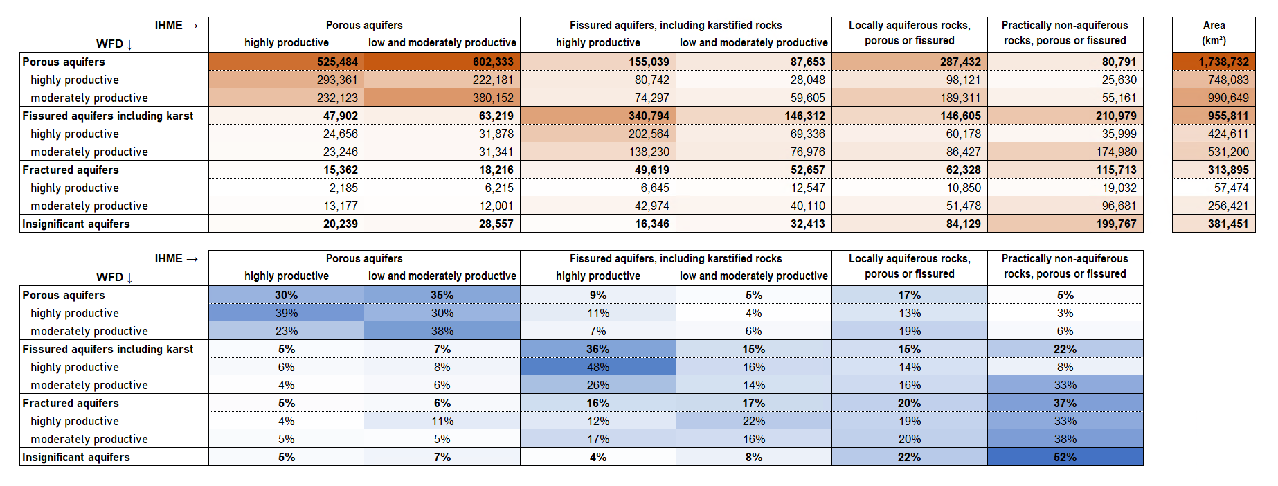
Figure 54 WFD geological formation and IHME1500 aquifer type.#
See detailed description
Column |
Description |
Example |
|---|---|---|
AQUIF_CODE |
Aquifer Type Code 1: Highly productive porous aquifers, Remark: Aquifer type 1 and 2 include less frequently fissured-porous aquifers and aquifer type 3 and 4 include less frequently porous-fissured aquifers. |
5 |
AQUIF_NAME |
Aquifer Type |
Highly productive porous aquifers |
SALTINTRUS |
Seawater Intrusion |
0 |
LEVEL1 |
Lithology Level 1 |
Quartzites, sandstones, shales, volcanic rocks |
LEVEL2 |
Lithology Level 2 |
Quartzites, sandstones |
LEVEL3 |
Lithology Level 3 |
Quartzites |
LEVEL4 |
Lithology Level 4 |
Metamorphic rocks |
LEVEL5 |
Lithology Level 5 |
Consolidated materials |
Copyright: IHME1500 v1.2 © BGR & UNESCO 2019
Citation: BGR & UNESCO (eds.) (2019): International Hydrogeological Map of Europe 1:1,500,000 (IHME1500). Digital map data v1.2. Hannover/Paris
Source: Documentation of the digital vector dataset. Description of the attribute tables. Shapefile: ihme1500__ec4060_v12_poly
Aquifer productivity#
See Figure 55: the CIS Guidance Document 2 does not provide quantitative guidelines,
beyond the mention to the 10 m3/d threshold for drinking water abstraction.
Does then the classification geologicalFormation = 'Insignificant aquifers'
mean that the aquifer is not relevant in terms of potential yield,
but is significant due to dependent surface water bodies,
or groundwater dependent ecosystem?
This should be clarified in the codelist definitions.
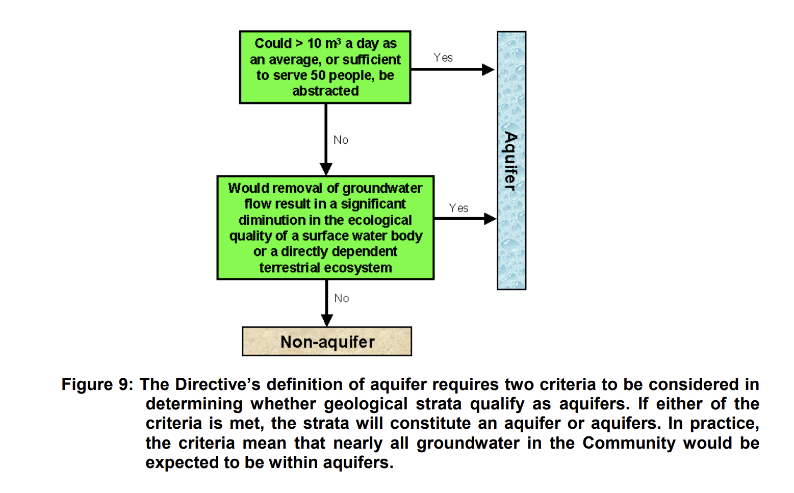
Figure 55 Criteria for definition of an aquifer (CIS Document 2).#
National documents vary, when addressing productivity in terms of potential long-term abstraction rate.
Example - Ireland 2026 [1]:
“Yield is one of the main concerns in aquifer development projects, yields from existing wells are conceptually linked with the main aquifer categories:
Regionally important (R) aquifers should have (or be capable of having) a large number of ‘excellent’ yields: in excess of approximately 400 m3/d.
Locally important (L) aquifers are capable of ‘good’ well yields 100-400 m3/d.
Poor (P) aquifers would generally have ‘moderate’ or ‘low’ well yields - less than 100 m3/d.”
Example - Scotland 2004 [5]:
“Productivity classes are a measure of the expected (i.e. potential) long-term abstraction rate of groundwater from a typical borehole at an individual abstraction site.”
Class
Range
Unit
Very high
(20,)
L/s
High
(10,20]
L/s
Moderate
(1,10]
L/s
Low
(0.1,1]
L/s
Very low
(0,0.1]
L/s
Reasons for failure#
Show code
1-- https://discodata.eea.europa.eu/
2
3SELECT [gwChemicalStatusValue]
4  ,[gwChemicalReasonsForFailure]
5  ,COUNT(DISTINCT [euGroundWaterBodyCode]) AS numberOfGroundWaterBodies
6  ,COUNT(DISTINCT [countryCode]) AS numberOfCountries
7FROM [WISE_WFD].[v2r1].[GWB_GroundWaterBody_gwChemicalReasonsForFailure]
8WHERE [cYear] = 2022 AND [hasDescriptiveData] = 1
9GROUP BY [gwChemicalStatusValue],[gwChemicalReasonsForFailure]
Show code
 1-- https://discodata.eea.europa.eu/
 2SELECT [numberOfReasonsForFailure],
 3COUNT(DISTINCT [euGroundWaterBodyCode]) AS [numberOfGroundWaterBodies],
 4COUNT(DISTINCT [countryCode]) AS [numberOfCountries]
 5FROM
 6(
 7SELECT [countryCode],[euGroundWaterBodyCode]
 8  ,COUNT(DISTINCT [gwChemicalReasonsForFailure]) AS [numberOfReasonsForFailure]
 9FROM [WISE_WFD].[v2r1].[GWB_GroundWaterBody_gwChemicalReasonsForFailure]
10WHERE [cYear] = 2022 AND [hasDescriptiveData] = 1
11GROUP BY [countryCode],[euGroundWaterBodyCode]
12) AS a
13GROUP BY [numberOfReasonsForFailure]
Show code
1-- https://discodata.eea.europa.eu/
2
3SELECT [gwQuantitativeStatusValue]
4  ,[gwQuantitativeReasonsForFailure]
5  ,COUNT(DISTINCT [euGroundWaterBodyCode]) AS numberOfGroundWaterBodies
6  ,COUNT(DISTINCT [countryCode]) AS numberOfCountries
7FROM [WISE_WFD].[v2r1].[GWB_GroundWaterBody_gwQuantitativeReasonsForFailure]
8WHERE [cYear] = 2022 AND [hasDescriptiveData] = 1
9GROUP BY [gwQuantitativeStatusValue],[gwQuantitativeReasonsForFailure]
Show code
 1-- https://discodata.eea.europa.eu/
 2
 3SELECT [numberOfReasonsForFailure],
 4  COUNT(DISTINCT [euGroundWaterBodyCode]) AS numberOfGroundWaterBodies,
 5  COUNT(DISTINCT [countryCode]) AS numberOfCountries
 6FROM
 7(
 8SELECT [countryCode],[euGroundWaterBodyCode]
 9  ,COUNT(DISTINCT [gwQuantitativeReasonsForFailure]) AS [numberOfReasonsForFailure]
10FROM [WISE_WFD].[v2r1].[GWB_GroundWaterBody_gwQuantitativeReasonsForFailure]
11WHERE [cYear] = 2022 AND [hasDescriptiveData] = 1
12GROUP BY [countryCode],[euGroundWaterBodyCode]
13) AS a
14GROUP BY [numberOfReasonsForFailure]
Natural background levels#
In the 3rd cycle, natural background levels (NBL) were reported for 8608 water bodies (38.6%) and over 90 substances.
An exploratory analysis shows the expected high frequency of reporting of NBLs for metals and metalloids (e.g. arsenic, cadmium or lead), major ions and nutrients (e.g. chloride, sulphate, ammonium or nitrate) and physico-chemical parameters like electrical conductivity (likely as an indicator of saline intrusion).
Other parameters are more unexpected and are likely due to reporting errors (e.g. chlorite instead of chloride).
More importantly, the values reported are sometimes physically impossible (e.g. above 1000mg/L) or clearly unlikely.
See table
parameterGroup |
parameter |
Countries |
WaterBodies |
|---|---|---|---|
Major Ions and Nutrients |
CAS_18785-72-3 - Sulphate |
19 |
4444 |
Major Ions and Nutrients |
CAS_16887-00-6 - Chloride |
20 |
4433 |
Major Ions and Nutrients |
CAS_14798-03-9 - Ammonium |
17 |
4328 |
Major Ions and Nutrients |
CAS_14797-55-8 - Nitrate |
11 |
4217 |
Major Ions and Nutrients |
CAS_14265-44-2 - Phosphate |
10 |
407 |
Major Ions and Nutrients |
CAS_14797-65-0 - Nitrite |
6 |
186 |
Major Ions and Nutrients |
CAS_16984-48-8 - Fluoride |
6 |
88 |
Major Ions and Nutrients |
CAS_7440-09-7 - Potassium |
4 |
80 |
Major Ions and Nutrients |
CAS_7440-23-5 - Sodium |
8 |
59 |
Major Ions and Nutrients |
CAS_7723-14-0 - Total phosphorus |
4 |
51 |
Major Ions and Nutrients |
CAS_7439-95-4 - Magnesium |
3 |
28 |
Major Ions and Nutrients |
CAS_7440-70-2 - Calcium |
3 |
28 |
Major Ions and Nutrients |
CAS_71-52-3 - Hydrogen Carbonate (Bicarbonate) HCO3 |
2 |
26 |
Metals and Metalloids |
CAS_7440-38-2 - Arsenic and its compounds |
18 |
4514 |
Metals and Metalloids |
CAS_7440-43-9 - Cadmium and its compounds |
13 |
4301 |
Metals and Metalloids |
CAS_7439-92-1 - Lead and its compounds |
11 |
4257 |
Metals and Metalloids |
CAS_7440-02-0 - Nickel and its compounds |
15 |
4170 |
Metals and Metalloids |
CAS_7439-97-6 - Mercury and its compounds |
10 |
4155 |
Metals and Metalloids |
CAS_7440-66-6 - Zinc and its compounds |
8 |
3954 |
Metals and Metalloids |
CAS_7440-47-3 - Chromium and its compounds |
8 |
3947 |
Metals and Metalloids |
CAS_7440-50-8 - Copper and its compounds |
5 |
3906 |
Metals and Metalloids |
CAS_7440-48-4 - Cobalt and its compounds |
2 |
3772 |
Metals and Metalloids |
CAS_7440-62-2 - Vanadium and its compounds |
2 |
3772 |
Metals and Metalloids |
CAS_7440-42-8 - Boron |
7 |
139 |
Metals and Metalloids |
CAS_7429-90-5 - Aluminium and its compounds |
7 |
135 |
Metals and Metalloids |
CAS_7439-89-6 - Iron and its compounds |
6 |
128 |
Metals and Metalloids |
CAS_7439-96-5 - Manganese and its compounds |
6 |
118 |
Metals and Metalloids |
CAS_7782-49-2 - Selenium and its compounds |
4 |
79 |
Metals and Metalloids |
CAS_7440-61-1 - Uranium |
3 |
74 |
Metals and Metalloids |
CAS_7440-39-3 - Barium |
2 |
71 |
Metals and Metalloids |
CAS_7439-98-7 - Molybdenum and its compounds |
1 |
70 |
Metals and Metalloids |
CAS_7440-28-0 - Thallium |
1 |
70 |
Metals and Metalloids |
CAS_7440-36-0 - Antimony |
3 |
8 |
Metals and Metalloids |
CAS_18540-29-9 - Chromium (VI) |
1 |
2 |
Physicochemical Parameters |
EEA_3142-01-6 - Electrical conductivity |
14 |
4179 |
Physicochemical Parameters |
EEA_3152-01-0 - pH |
2 |
27 |
Physicochemical Parameters |
EEA_3121-01-5 - Water temperature |
1 |
1 |
undefined |
CAS_14998-27-7 - Chlorite |
1 |
138 |
undefined |
CAS_1231244-60-2 - Metazachlor OA |
1 |
70 |
undefined |
CAS_172960-62-2 - Metazachlor ESA |
1 |
70 |
undefined |
CAS_67129-08-2 - Metazachlor |
1 |
70 |
undefined |
CAS_108-95-2 - Phenol |
1 |
49 |
undefined |
CAS_122-34-9 - Simazine |
1 |
27 |
undefined |
CAS_5915-41-3 - Terbuthylazine |
1 |
27 |
undefined |
CAS_1031-07-8 - Endosulfan sulfate |
1 |
26 |
undefined |
CAS_1066-51-9 - Aminomethylphosphonic acid (AMPA) |
1 |
26 |
undefined |
CAS_1071-83-6 - Glyphosate |
1 |
26 |
undefined |
CAS_118-74-1 - Hexachlorobenzene |
1 |
26 |
undefined |
CAS_152019-73-3 - Metolachlor OA |
1 |
26 |
undefined |
CAS_1582-09-8 - Trifluralin |
1 |
26 |
undefined |
CAS_15972-60-8 - Alachlor |
1 |
26 |
undefined |
CAS_1912-24-9 - Atrazine |
1 |
26 |
undefined |
CAS_2212-67-1 - Molinate |
1 |
26 |
undefined |
CAS_2921-88-2 - Chlorpyrifos |
1 |
26 |
undefined |
CAS_298-00-0 - Parathion-methyl |
1 |
26 |
undefined |
CAS_309-00-2 - Aldrin |
1 |
26 |
undefined |
CAS_330-54-1 - Diuron |
1 |
26 |
undefined |
CAS_33213-65-9 - Beta-Endosulfan |
1 |
26 |
undefined |
CAS_34123-59-6 - Isoproturon |
1 |
26 |
undefined |
CAS_3424-82-6 - o,p’-DDE |
1 |
26 |
undefined |
CAS_465-73-6 - Isodrin |
1 |
26 |
undefined |
CAS_470-90-6 - Chlorfenvinphos |
1 |
26 |
undefined |
CAS_50-29-3 - DDT, p,p’ |
1 |
26 |
undefined |
CAS_53-19-0 - o,p’-DDD |
1 |
26 |
undefined |
CAS_56-38-2 - Parathion |
1 |
26 |
undefined |
CAS_60-57-1 - Dieldrin |
1 |
26 |
undefined |
CAS_608-73-1 - Hexachlorocyclohexane |
1 |
26 |
undefined |
CAS_608-93-5 - Pentachlorobenzene |
1 |
26 |
undefined |
CAS_72-20-8 - Endrin |
1 |
26 |
undefined |
CAS_72-55-9 - p,p’-DDE |
1 |
26 |
undefined |
CAS_76-44-8 - Heptachlor |
1 |
26 |
undefined |
CAS_87-86-5 - Pentachlorophenol |
1 |
26 |
undefined |
CAS_959-98-8 - Alpha-Endosulfan |
1 |
26 |
undefined |
EEA_32-03-1 - Total DDT (DDT, p,p’ + DDT, o,p’ + DDE, p,p’ + DDD, p,p’) |
1 |
26 |
undefined |
EEA_34-01-5 - Pesticides (Active substances in pesticides, including their relevant metabolites, degradation and reaction products) |
2 |
17 |
undefined |
CAS_64743-03-9 - Phenols |
1 |
10 |
undefined |
CAS_67-66-3 - Trichloromethane |
1 |
9 |
undefined |
EEA_3133-06-0 - Total organic carbon (TOC) |
1 |
7 |
undefined |
CAS_14866-68-3 - Chlorates |
1 |
4 |
undefined |
CAS_6190-65-4 - Desethylatrazine |
1 |
4 |
undefined |
EEA_33-42-1 - Total trichloroethylene + tetrachloroethylene |
2 |
4 |
undefined |
CAS_50-32-8 - Benzo(a)pyrene |
1 |
3 |
undefined |
EEA_33-19-2 - Mono basic phenols |
1 |
2 |
undefined |
CAS_124-48-1 - Dibromochlorometane |
1 |
1 |
undefined |
CAS_127-18-4 - Tetrachloroethylene |
1 |
1 |
undefined |
CAS_1333-82-0 - Chromium trioxide (CrO3) |
1 |
1 |
undefined |
CAS_79-01-6 - Trichloroethylene |
1 |
1 |
undefined |
CAS_86-73-7 - Fluorene |
1 |
1 |
undefined |
CAS_886-50-0 - Terbutryn |
1 |
1 |
undefined |
EEA_3133-04-8 - CODMn |
1 |
1 |
undefined |
EEA_33-05-6 - BTEX |
1 |
1 |
undefined |
EEA_33-29-4 - Surfactants (anionic) |
1 |
1 |
Show code
 1-- https://discodata.eea.europa.eu/
 2SELECT ISNULL(b.[parameterGroup],'undefined') AS [parameterGroup]
 3      ,[gwPollutantCode] AS [parameter]
 4      ,COUNT(DISTINCT [countryCode]) AS nCountries
 5      ,COUNT(DISTINCT [euGroundWaterBodyCode]) AS nWaterBodies
 6  FROM [WISE_WFD].[v2r1].[GWB_GroundWaterBody_GWPollutant] a
 7  LEFT JOIN (
 8  SELECT *
 9    FROM (VALUES
10    ('Metals and Metalloids', 'CAS_7429-90-5', 'Aluminium and its compounds'),
11    ('Metals and Metalloids', 'CAS_7440-36-0', 'Antimony'),
12    ('Metals and Metalloids', 'CAS_7440-38-2', 'Arsenic and its compounds'),
13    ('Metals and Metalloids', 'CAS_7440-39-3', 'Barium'),
14    ('Metals and Metalloids', 'CAS_7440-42-8', 'Boron'),
15    ('Metals and Metalloids', 'CAS_7440-43-9', 'Cadmium and its compounds'),
16    ('Metals and Metalloids', 'CAS_7440-47-3', 'Chromium and its compounds'),
17    ('Metals and Metalloids', 'CAS_18540-29-9', 'Chromium VI'),
18    ('Metals and Metalloids', 'CAS_7440-48-4', 'Cobalt and its compounds'),
19    ('Metals and Metalloids', 'CAS_7440-50-8', 'Copper and its compounds'),
20    ('Metals and Metalloids', 'CAS_7439-89-6', 'Iron and its compounds'),
21    ('Metals and Metalloids', 'CAS_7439-92-1', 'Lead and its compounds'),
22    ('Metals and Metalloids', 'CAS_7439-96-5', 'Manganese and its compounds'),
23    ('Metals and Metalloids', 'CAS_7439-97-6', 'Mercury and its compounds'),
24    ('Metals and Metalloids', 'CAS_7439-98-7', 'Molybdenum and its compounds'),
25    ('Metals and Metalloids', 'CAS_7440-28-0', 'Thallium'),
26    ('Metals and Metalloids', 'CAS_7440-02-0', 'Nickel and its compounds'),
27    ('Metals and Metalloids', 'CAS_7782-49-2', 'Selenium and its compounds'),
28    ('Metals and Metalloids', 'CAS_7440-61-1', 'Uranium'),
29    ('Metals and Metalloids', 'CAS_7440-62-2', 'Vanadium and its compounds'),
30    ('Metals and Metalloids', 'CAS_7440-66-6', 'Zinc and its compounds'),
31    ('Major Ions and Nutrients', 'CAS_14798-03-9', 'Ammonium'),
32    ('Major Ions and Nutrients', 'CAS_7440-70-2', 'Calcium'),
33    ('Major Ions and Nutrients', 'CAS_16887-00-6', 'Chloride'),
34    ('Major Ions and Nutrients', 'CAS_16984-48-8', 'Fluoride'),
35    ('Major Ions and Nutrients', 'CAS_71-52-3', 'Hydrogen Carbonate Bicarbonate HCO3'),
36    ('Major Ions and Nutrients', 'CAS_7439-95-4', 'Magnesium'),
37    ('Major Ions and Nutrients', 'CAS_14797-55-8', 'Nitrate'),
38    ('Major Ions and Nutrients', 'CAS_14797-65-0', 'Nitrite'),
39    ('Major Ions and Nutrients', 'CAS_14265-44-2', 'Phosphate'),
40    ('Major Ions and Nutrients', 'CAS_7440-09-7', 'Potassium'),
41    ('Major Ions and Nutrients', 'CAS_7440-23-5', 'Sodium'),
42    ('Major Ions and Nutrients', 'CAS_18785-72-3', 'Sulphate'),
43    ('Major Ions and Nutrients', 'CAS_7723-14-0', 'Total phosphorus'),
44    ('Physico-chemical Parameters', 'EEA_3142-01-6', 'Electrical conductivity'),
45    ('Physico-chemical Parameters', 'EEA_3152-01-0', 'pH'),
46    ('Physico-chemical Parameters', 'EEA_3121-01-5', 'Water temperature')
47) AS v(parameterGroup, parameterCode, name) ) b
48
49    ON a.[gwPollutantCode] like b.parameterCode+' - %'
50
51  WHERE a.[gwPollutantBackgroundLevelSet] = 'yes'
52      AND a.[cYear] = 2022
53      AND a.[hasDescriptiveData] = 1
54      AND a.[gwPollutantCode] != 'EEA_00-00-0 - Other parameter'
55  GROUP BY a.[gwPollutantCode]
56      ,b.[parameterGroup]
57  ORDER BY 1, 4 desc, a.[gwPollutantCode]